BERLIN JOINS UBCAS CITY NUMBER 100!
 In June of this year Berlin had the great honor of being accepted as the 100th member of the UBC. The most important association of cities in the Baltic Sea Region has taken up the tradition of a community that once decisively shaped the entire region: the Hanseatic League. At the same time, it extends far beyond the trade and merchants' alliance that united us from the Middle Ages until the early modern era, transcending linguistic and national boundaries. In June of this year Berlin had the great honor of being accepted as the 100th member of the UBC. The most important association of cities in the Baltic Sea Region has taken up the tradition of a community that once decisively shaped the entire region: the Hanseatic League. At the same time, it extends far beyond the trade and merchants' alliance that united us from the Middle Ages until the early modern era, transcending linguistic and national boundaries.
Certainly, economic ties play a significant role even today. In addition to exchange on the commercial and economic level, however, cultural and political exchanges are also important. We can now find common ground, freely and unhindered, whereas the political division of Europe and the disregard for independence and sovereignty rights had made this impossible for decades.
The urban centers determine the pace of development in this respect. Berlin is a crossroads on the communication and trade routes to and from Central, Eastern, and Northern Europe. The Baltic Sea is an inland sea not only in the geographic sense; these waters have long since connected us more than they separate us. Tourism makes an important contribution to this. The Baltic Sea is a favorite recreation spot not only for the people of Berlin.
The 10th anniversary of the UBC and its general conference in Rostock offer the opportunity to reflect on the successes it has achieved. During a decade of fundamental change, it has contributed significantly to increasing the awareness of what unites the Baltic Sea Region. The UBC demonstrates unity within diversity and lends the cities particular weight in the formation of ties in the Baltic Sea area.
Governing Mayor of Berlin, Klaus Wowereit
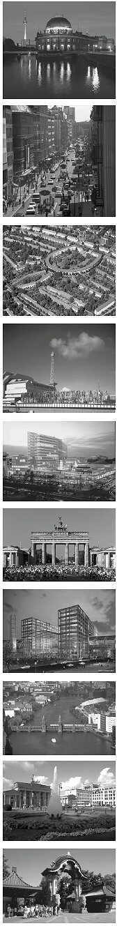
Berlin – A City on the Waterfront
Berlin's inner city waterways are unlike those in any other European capital. Nearly seven percent of Berlin's total area is water, with approximately 200 kilometers of waterways meandering through the city. There are so many water sport and recreational areas that even on the hottest summer days, only a few spots are congested with city dwellers heading to the outlaying areas beyond this city of millions. Unlike the urbanites of other cities, Berliners start not with the outlaying regions, but rather within their own city limits. The end of the Kurfürstendamm is actually the beginning of a series of Grunewald lakes. Together with the course of the river Havel, they make the Grunewald particularly attractive. Treptower Park, an old favorite amongst Berliners, opens up towards the river Spree's broad course with the Stralauer peninsula and Rummelsburger Bay. Beyond the city limits in Brandenburg, the number of waterways and lakes lies not in the hundreds, but rather closer to four thousand.
The Spree and Landwehrkanal
In contrast to the Landwehrkanal, the river Spree plays a secondary role in the Berlin cityscape. Whereas residential housing, office space, public buildings and beautiful walkways are common along the Landwehrkanal. The reasons for this can be traced to Berlin's origins as a city of two separate settlements separated by a fordable crossing of the river Spree. The walls dividing the separate settlements hindered free use of the canal for long stretches, which added to the image of a divided city.
A boat ride along the Spree's waterways is a unique experience. In Paris, Rome or Stockholm boat rides are attractive because they offer a changed perspective on views from the banks. The Spree offers views into areas visible only from the water itself.
A Transport Route for Capital Projects
The Spree continues to be the transport route for industrial traffic – whether it be the trans-shipment of goods from harbors, shipping building materials, fuel for power plants, or as in earlier days serving as a route for the fishing industry – the barge upon which the city was built. The industrial history of Berlin has shaped the landscape of its riverbanks. It was with de-industrialization following the fall of the Berlin Wall that the transportation of goods along the Spree and Havel began to decrease. However, together with the railways, water transport routes along the Spree and Landwehrkanal played a major logistical role in the large construction projects of the nineties at Potsdamer Platz for the DaimlerChrysler Areal and the Sony-Center, and those along the Spreebogen for the Reichstag reconstruction, the building of the Federal Chancellery and the Parliament buildings.
Spandau and Rummelsburger Bay
The city's unification started a fundamental change. The urban planning potential of Berlin's waterways and their accompanying streets is becoming more and more prevalent. Furthermore, Berlin's de-industrialization opens up the opportunity to rediscover water as a location factor. There are numerous excellent locations for apartments, offices, industry, or tourist attractions. Nearly 330 kilometers of lake, river and canal banks offer development opportunities. At the beginning of the nineties, the state of Berlin designated six areas of development, two of which concerned explicitly the topic of a new city of waterways: the development areas of Berlin Oberhavel in Spandau as a "water city" and the EXPO 2000 project Rummelsburger Bay on the Stralauer Spree, which is only five kilometers from Alexanderplatz. These are the two largest projects in which former industrial areas are being transformed into new living spaces. Berlin's waterways are in general safe for bathing and fish counts are rising with the continued improved water quality.
Industrial Buildings and Warehouses Along the Spree
Other large projects along the Spree and Havel such as the Spreebogen in Moabit, the Federal Chancellery and the Lehrter Bahnhof are creating new relationships between water and the city in its center. A new city is arising from the vacant storage halls along the Osthafen. In southeast Berlin's Oberschöneweide, industrial buildings of old city quarters along the bend of the river Spree are coming back to life. Portions of the Osthafen and its connecting riverbank zone at the Ostbahnhof behind the "East Side Gallery", which reaches into downtown, will soon become the largest and most valuable waterfront development area. A new kind of apartment and service building development is taking place in Berlin, in which historical industrial buildings are not torn down, but rather renovated and used for other purposes. The new waterfront living quarters in particular will provide fresh opportunities for Berlin. A good quality of living belongs once again inside the city boundaries and the city belongs once again to its waterways.
To the Parliament House Via Water Taxi
It is said that Berlin has more bridges than Venice. The Senate Administration for City Development alone is responsible for 951 bridges, of which nearly forty percent belong to the Office of Shipping and Waterways. Considering Berlin's size, there lurks behind these large numbers a city development problem which every city on a river must face: there are not enough river crossings.
Water taxis are planned for those stretches along the Spree where bridges lie far apart. These small double-hulled vessels that can reach a speed of 15 kilometers an hour will turn the Spree into a passing lane along the congested streets, like their Venetian models. The city center's new topography will have enough destinations that would draw more than enough customers: soon visitors to Berlin will be able to transfer from a high-speed train (opening in the Summer of 2006) to a waterway. The Reichstag building, Parliament offices and chamber halls, the Ministry of the Interior, the Foreign Ministry, Schloss Bellevue and the Federal President's residency all lie directly on the waterfront. The Federal Press Office, Ministry for the Environment, Federal Press Conference and ARD's capital headquarters are within reach of the Spree, just like the Friedrichstraße train station and a number of cultural spots such as the Berliner Ensemble, the House of World Cultures, the Charlottenburger Palace, the Museum Island, the German Historical Museum, the Berliner Dom, the Friedrichstadtpalast or the Maxim-Gorki-Theater.
Berlin's Drinking Water
Berlin is characterized not by its visible rivers and canals alone. The city literally lives from its ground water. Whereas other cities must as a rule pump their water supply from surrounding regions, Berlin supplies itself with drinking water from its own territory. Berlin's groundwater is a delicious earthly good. The expensive methods of the last few years used in the construction between Potsdamer Platz and Lehrter Bahnhof were certainly no waste of money. Berlin's delicate ground water level could thus be maintained and measures to keep lowered levels in the neighboring areas.
Water as foodstuff, waterways and canals as living spaces: Berlin relies on its wealth of water. This is just the start of a new relationship between the city and its waterways.
|