Jekabpils in Struve Geodetic Arc
The international conference "Struve
geodetic Arc: its continuation in time and space" was
held on 22 August in Jekabpils, Latvia.
 The
Struve Arc is a chain of survey triangulations stretching
from Hammerfest in Norway to the Black Sea, through 10 countries
and over 2,820 km. These are points of a survey, carried
out between 1816 and 1855 by the astronomer Friedrich Georg
Wilhelm Struve, which represented the first accurate measuring
of a long segment of a meridian. This helped to establish
the exact size and shape of the planet and marked an important
step in the development of earth sciences and topographic
mapping. The original arc consisted of 258 main triangles
with 265 main station points. The listed site includes 34
of the original station points, with different markings,
i.e. a drilled hole in rock, iron cross, cairns, or built
obelisks. Latvia has undertaken special responsibility for
two geodetic points -Jekabpils and Sestukalns, because they
are on the World Cultural and Natural Heritage List. W.
Struve's intention to include triangulation triangles of
Livonia and of Estonia into section of the common meridian
arc was realized through Jekabpils. Astronomical station
Jekabpils was established and surveyed in May -June 1826.
In the course of time the astronomical station Jekabpils
remained undestroyed. The
Struve Arc is a chain of survey triangulations stretching
from Hammerfest in Norway to the Black Sea, through 10 countries
and over 2,820 km. These are points of a survey, carried
out between 1816 and 1855 by the astronomer Friedrich Georg
Wilhelm Struve, which represented the first accurate measuring
of a long segment of a meridian. This helped to establish
the exact size and shape of the planet and marked an important
step in the development of earth sciences and topographic
mapping. The original arc consisted of 258 main triangles
with 265 main station points. The listed site includes 34
of the original station points, with different markings,
i.e. a drilled hole in rock, iron cross, cairns, or built
obelisks. Latvia has undertaken special responsibility for
two geodetic points -Jekabpils and Sestukalns, because they
are on the World Cultural and Natural Heritage List. W.
Struve's intention to include triangulation triangles of
Livonia and of Estonia into section of the common meridian
arc was realized through Jekabpils. Astronomical station
Jekabpils was established and surveyed in May -June 1826.
In the course of time the astronomical station Jekabpils
remained undestroyed.
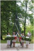
Nowadays the municipality has taken responsibility
for the preserving of this cultural heritage place and there
was a new triangulation tower point model designed and built
in the same historic place. The representatives of the international
conference from Struve geodetic arc countries were the witnesses
of its opening ceremony.
|